About Julia Pfeiffer Burns State Park

Julia Pfeiffer Burns State Park stretches from the Big Sur coastline into nearby 3,000-foot ridges. The park features redwood, tan oak, madrone, chaparral, and an 80-foot waterfall that drops from granite cliffs into the The park also has a 1,680-acre underwater reserve which protects a spectacular assortment of marine life. Special-use permits allow experienced divers to explore the reserve. Seals, sea lions and sea otters can be seen in the park's cove. Hikers can discover the park's backcountry via several trail systems. There is no park kiosk at Julia Pfeiffer Burns State Park for fee collection. Campers should register at Pfeiffer Big Sur State Park or Big Sur Station. For Special Events in the parks such as weddings and small celebrations, please e-mail Special Events at BigSurEvents@parks.ca.gov.

Get directions through Google Maps

The park is 37 miles south of Carmel on Hwy 1, and 12 miles south of Pfeiffer Big Sur SP on Hwy 1.

EV Information

e-bike icon E-Bike Locations
  EV Charger Locations

Overnight Facilities

  • Environmental Campsites
Other Facilities

  • Parking
  • Restrooms
  • Drinking Water Available
Day-Use Activities & Facilities

  • Picnic Areas
  • Exhibits and Programs
  • Interpretive Exhibits
  • Nature & Wildlife Viewing
Trail Use

  • Hiking Trails
Wildlife Sanctuary and Educational Programs

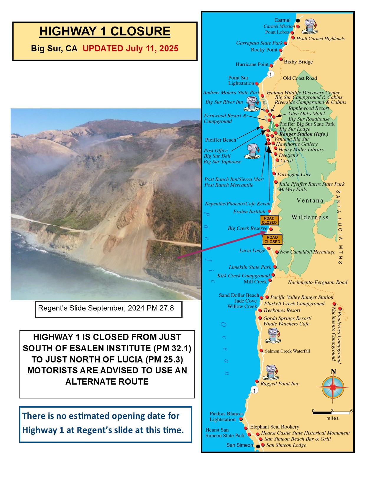
HIGHWAY 1 CLOSURES

Northbound / Southbound 1 Full Closure

From Turnout South of Vicente Creek to Turnout South of Lime Creek

Due to Emergency Work
No estimated time for reopening of closure.
Information courtesy of 

Last updated: 07/11/2025


Highway Closure Map


About Julia Pfeiffer Burns State Park

* * * CLOSED AREAS ***
THERE IS NO BEACH OR OCEAN ACCESS at McWAY FALLS

Cliff areas beyond the fenced boundaries, including the BEACH, SADDLE ROCK and MCWAY FALLS area are completely off limits. Trespassing into these closed areas is a serious offense, resulting in a citation and arrest. The areas are extremely hazardous. Failure to respect the boundaries has resulted in complex rescue operations and tragic loss of lives. Please stay on the trail and out of these closed areas.

This state park is named after Julia Pfeiffer Burns, a well-respected pioneer woman in the Big Sur country. The park stretches from the Big Sur coastline into nearby 3,000-foot ridges. It features redwood, tan oak, madrone, chaparral, and an 80-foot waterfall that drops from granite cliffs into the ocean waters of Monterey Bay National Marine Sanctuary. The higher elevation trails east of Highway 1 (currently closed) offer panoramic views of the sanctuary and miles of rugged coastline.

Weather
 CHECK CURRENT WEATHER
The weather can be changeable. Layered clothing is advised. In winter, overnight temperatures can range in the 30s-50s (Fahrenheit). Winter daytime temperatures can be low 50s-70s. In summer, overnight temperatures can range in the 50s-70s, with daytime temperatures typically in the 70s-80s. Summer mornings bring fog, which usually burns off by midday.

Location
Near mile marker 35.8 on Highway 1, the park is 37 miles south of Carmel.
 GOOGLE MAP


Julia Pfeiffer Burns SP