Day-Use Reservations Required for Summer 2026
Make your day-use reservation
To reduce the impacts of overcrowding and to create a significantly improved visitor experience, California State Parks will begin a pilot program requiring reservations to visit McArthur-Burney Falls Memorial State Park (Burney Falls) on Friday-Sunday and holidays during peak visitation season, starting Friday, May 15, through Sunday, Sept. 27.

Do I need a day-use
reservation at Burney Falls?
No
Reservation
Needed
Reservation
Needed
January – May 14
May 15 – September
Monday – Thursday
Monday – Thursday
October – December
Advance
Reservation
Required*
Reservation
Required*
May 15 – September
Friday – Sunday
Friday – Sunday
Memorial Day, Fourth of July,
and Labor Day
and Labor Day
Number of Vehicle Passes Issued Daily
8 a.m.–noon — 103 passes
1–5 p.m. — 103 passes
All day — 35 passes
*Pass quantities may be adjusted based on impacts from new reservation process. Reservations limited to one per vehicle per day. Vehicles must be passenger vehicles requiring only one standard-size parking space. Guests with a campground or cabin reservation will not need to make a separate day-use reservation. Day-users with a boat reservation from the concessionaire-operated marina will need to also make a day-use reservation.
Under the pilot program, reservations purchased in advance via LAZ Parking will be required for day-use entry. The park will offer 103 parking passes valid between 8 a.m. and noon, an additional 103 passes valid between 1 and 5 p.m., and 35 passes valid for the entire day. The cost will be $10 per vehicle plus a dollar processing fee. Senior and disabled discounts apply if eligible, as well as entry for annual pass holders, though reservations are still required. Same-day reservations will not be accepted.
McArthur Burney Hospitality, LLC currently operates the dock, cabin rentals, and the Burney Falls General Store™.
Visitors,
McArthur Burney Falls State Park experiences extremely high visitation beginning in April and continuing through October. Most weekends all summer the park will fill to capacity and entrance into the park is subject to closure due to limited parking availability. Visitors should expect traffic delays on State Highway 89 for up to an hour prior to entering the park due to the increased visitation experienced at this park. It is illegal to park along Highway 89 outside of the park for a mile either direction. If you park along Highway 89 your vehicle will be subject to citation and tow. The speed limit is 55 mph along Highway 89 and utilized by a large volume of semitrucks, it is not recommended to walk along the highway. If you arrive to find the entrance closed due to full capacity, please return at a later time - typically after 4:00 p.m.
 Note: The park cannot admit entrance to vehicles over 32 feet for day-use or camping. Additionally, only a limited number of oversized vehicles (less than 32 feet in length) will be admitted into park. Oversized vehicles will only be allowed to park in the Lake Britton parking lot (approximately 1.5 miles walk to the falls) on Fridays, Saturdays, and Sundays.
Due to limited parking capacity, McArthur-Burney Falls Memorial State Park cannot accommodate entry, drop-offs or parking of tour busses until further notice.
McArthur Burney Falls State Park experiences extremely high visitation beginning in April and continuing through October. Most weekends all summer the park will fill to capacity and entrance into the park is subject to closure due to limited parking availability. Visitors should expect traffic delays on State Highway 89 for up to an hour prior to entering the park due to the increased visitation experienced at this park. It is illegal to park along Highway 89 outside of the park for a mile either direction. If you park along Highway 89 your vehicle will be subject to citation and tow. The speed limit is 55 mph along Highway 89 and utilized by a large volume of semitrucks, it is not recommended to walk along the highway. If you arrive to find the entrance closed due to full capacity, please return at a later time - typically after 4:00 p.m.
Due to limited parking capacity, McArthur-Burney Falls Memorial State Park cannot accommodate entry, drop-offs or parking of tour busses until further notice.
McArthur Burney Falls Memorial State Park entrance kiosk is closed in the off-season. Please bring exact change or credit/debit cards to pay by APM (Automatic Payment Machine) which is located just pass the entrance kiosk in front of the visitor center.
- Park Day-Use Fee - $10 Per Vehicle
- Overnight Camping - $35 Per Night (Includes One Vehicle).
- Additional Overnight Camping Vehicles - $10 Per night.
Pet Information:
- We recommend you leave all pets at home as they are not allowed on the trails surrounding the falls (CCR 4312(f)), on the beach at Lake Briton (CCR4312(f)), or allowed to be left unattended in your vehicle (CVC 497.7(a)).
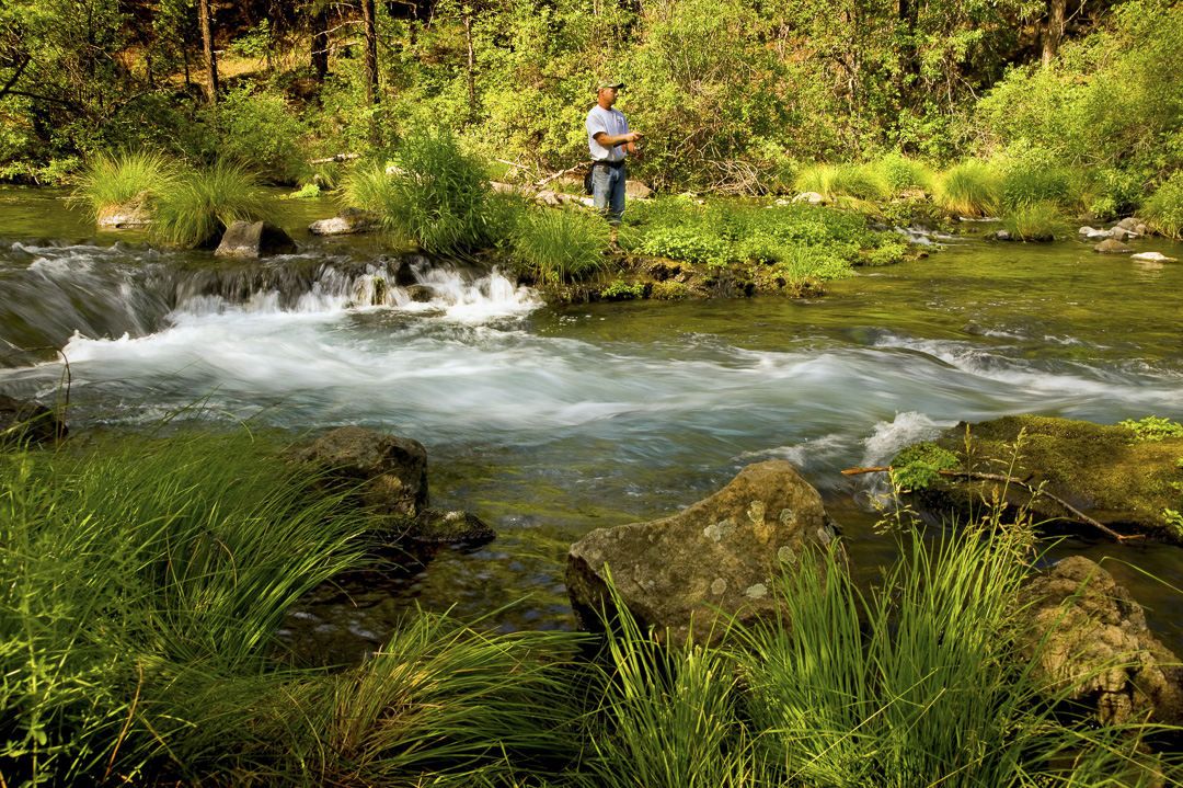
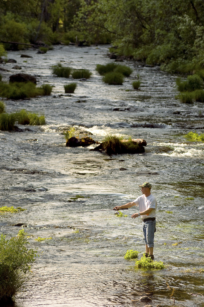
The park is within the Cascade Range and Modoc Plateau natural region, with forest and five miles of streamside and lake shoreline, including a portion of Lake Britton.
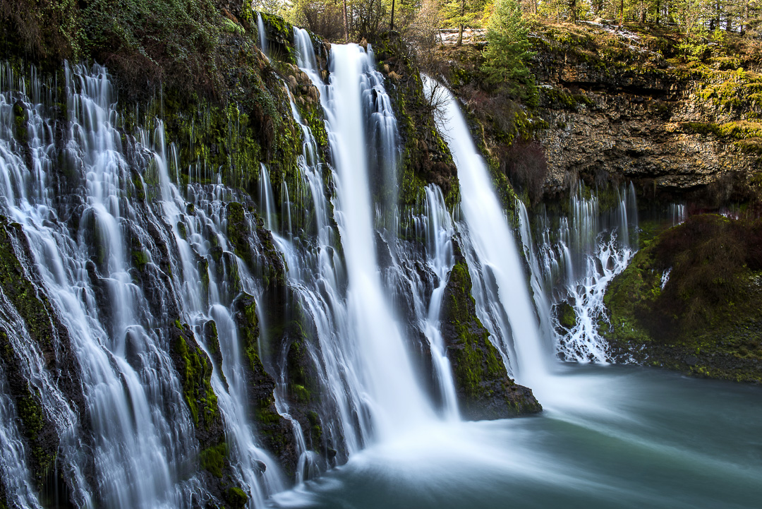
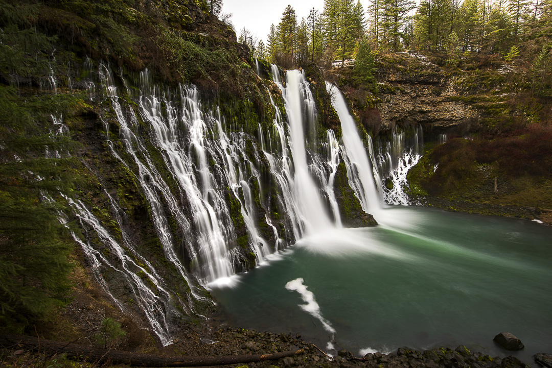
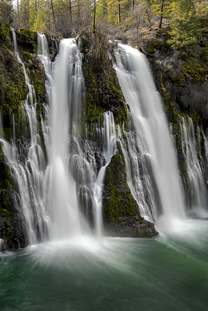
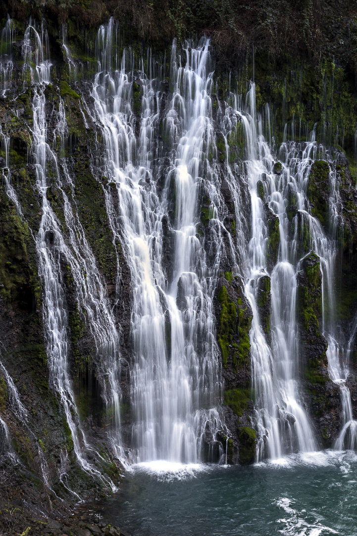
The park's centerpiece is the 129-foot Burney Falls, which is not the highest or largest waterfall in the state, but possibly the most beautiful. Additional water comes from springs, joining to create a mist-filled basin. Burney Creek originates from the park's underground springs and flows to Lake Britton, getting larger along the way to the majestic falls.
The park's landscape was created by volcanic activity as well as erosion from weather and streams. This volcanic region is surrounded by mountain peaks and is covered by black volcanic rock, or basalt. Created over a million years ago, the layered, porous basalt retains rainwater and snow melt, which forms a large underground reservoir.
Within the park, the water emerges as springs at and above Burney Falls, where it flows at 100 million gallons every day.
Burney Falls was named after pioneer settler Samuel Burney who lived in the area in the 1850s. The McArthurs were pioneer settlers who arrived in the late 1800s. Descendants were responsible for saving the waterfall and nearby land from development. They bought the property and gave it to the state as a gift in the 1920s.
Special Events
On the Sunday of Columbus Day weekend, the park hosts Heritage Day, featuring demonstrations and recreations of activities and crafts common to people during the late 19th century.
Hiking
There are five miles of hiking trails winding through the park's evergreen forests. The Pacific Crest Trail passes through the park.
Location-Directions
The park is northeast of Redding, six miles north of Highway 299 on Highway 89 near Burney.
Seasons/Climate/Recommended Clothing
Summer and spring are warm; fall and winter can be cool. Layered clothing is advised.