Summer Day Use
We are open and welcome to DL Bliss!
During the summer, the park is open for day use from sunrise to sunset. Visitors can enjoy hiking, picnicking, and beach time at DL Bliss SP. It is a popular destination and it is recommended to come early morning or the afternoon to access parking. Display your parking receipt or CA State Parks Pass on your vehicle dash.
When the parking lots have filled for Day Users, visitors will have to park at the visitor center at the top of Bliss hill. The Visitor Center parking lot is near highway 89 and the visitor center is open on weekends. It is approximately 1 mile to hike from the Vistor Center to the closest Rubicon Trailhead, and a steep mountainous 2 mile hike to the beaches.
Day Use Reminders:
No Drones
No Smoking
No Wood/Charcoal BBQ/fires (Propane/gas is fine)
All children under 13 yrs must wear a life jacket on a kayak or paddleboard
Any person over 13 yrs on a kayak or paddleboard must have a life jacket on the vessel
Dogs are not allowed on the beaches or dirt trails in CA State Parks.
Summer Camping
For camping reservations for 2026, call Reserve California at 1-800-444-PARK (7275) or visit www.reservecalifornia.com.
Reservations can be made 6 months in advance of the date you would like to arrive. The Lake Tahoe area is a popular destination and reservations are recommended.
Fees for family camping are $35 ($45 Beach Camp) per night (8 people). Fees include one vehicle (towed vehicles exempt). Second vehicle is $10 per night. Not all sites can hold 2 vehicles.
The campground was built in 1934 and the parking pads are small. Vehicles must park on parking pads. If needed there is overflow parking at Balancing Rock parking lot.
Occupancy and vehicle limits are posted on www.reservecalifornia.com.
The group site allows up to 40 people for $165 a night.
The campground does not have hook-ups. Showers and dump station are available for registered campers.
Shower tokens will be available at the kiosk when the kiosk is open.
Check In 2 pm
Check Out Noon
2 Vehicles allowed per campsite
8 people allowed per campsite
Generator Hours 10am - 8pm
Quiet Hours 10pm - 6am
No Drones
Vehicles must be parked on pavement
Amplified music is only allowed with a permit
Dogs must be leashed and never unattended. No dogs on beaches or trails.
Children must have helmets for bicycles/scooters/skateboards
All state vehicle codes apply on campground roads. No passengers in truckbeds.
Food must be stored DAY and NIGHT
Food Storage Locker Information - Important and required.
All food, beverages, toiletries, and trash containing food/smells are required by law to be stored in provided food lockers except when food is being prepared or eaten. Black bears are currently very active at Bliss campground as they are just waking from a long winter and are very interested in ALL items that smell like food. Metal bear-resistant food lockers are provided in each campsite. Ice chests may NOT be stored in vehicles and shall be stored in the food storage locker. The inside dimensions of the food lockers 36" deep, 43" wide, and 22" high. Violations will be cited.
Attention: Bear-Proof Cooler Owners  BEAR-PROOF COOLERS (Yeti, Pelican, Yukon etc.) MUST be secured with locks per manufacturer instructions in order to meet Interagency Grizzly Bear
  Committee (IGBC) standards. Failure to do so may result in a Food Storage Citation and up to a $1000 Fine Title XIV CCR 4323(b). It is recommended that a cable lock is also used to attach the bear cooler to a non moveable item. Bears are known to take off with and/or toss coolers around to try to open them. More information available in our Black Bear Brochure.
BEAR-PROOF COOLERS (Yeti, Pelican, Yukon etc.) MUST be secured with locks per manufacturer instructions in order to meet Interagency Grizzly Bear Committee (IGBC) standards. Failure to do so may result in a Food Storage Citation and up to a $1000 Fine Title XIV CCR 4323(b). It is recommended that a cable lock is also used to attach the bear cooler to a non moveable item. Bears are known to take off with and/or toss coolers around to try to open them. More information available in our Black Bear Brochure.Location - Directions
D.L Bliss SP is located 17 miles south of Tahoe City on Highway 89 and 11 miles north of South Lake Tahoe.
Seasons/Climate Recommended Clothing
Summer temperatures range from about 75-80 degrees F during the day to the low 40s at night, and winter temperatures average from a high of 40 to lows in the teens and 20s; Winter temperatures may dip below 0 degrees F.
High Sierra weather is varied and can change abruptly. It is recommended to bring layered clothing and check weather updates. Weather forecast is available at NOAA.
Chains and/ or 4 wheel drive are frequently required during the winter season. For up to date road conditions, call the Caltrans road hotline at 1800-427-ROAD, or visit the Caltrans website.
D.L. Bliss State Park is located off of Highway 89.
About the Park
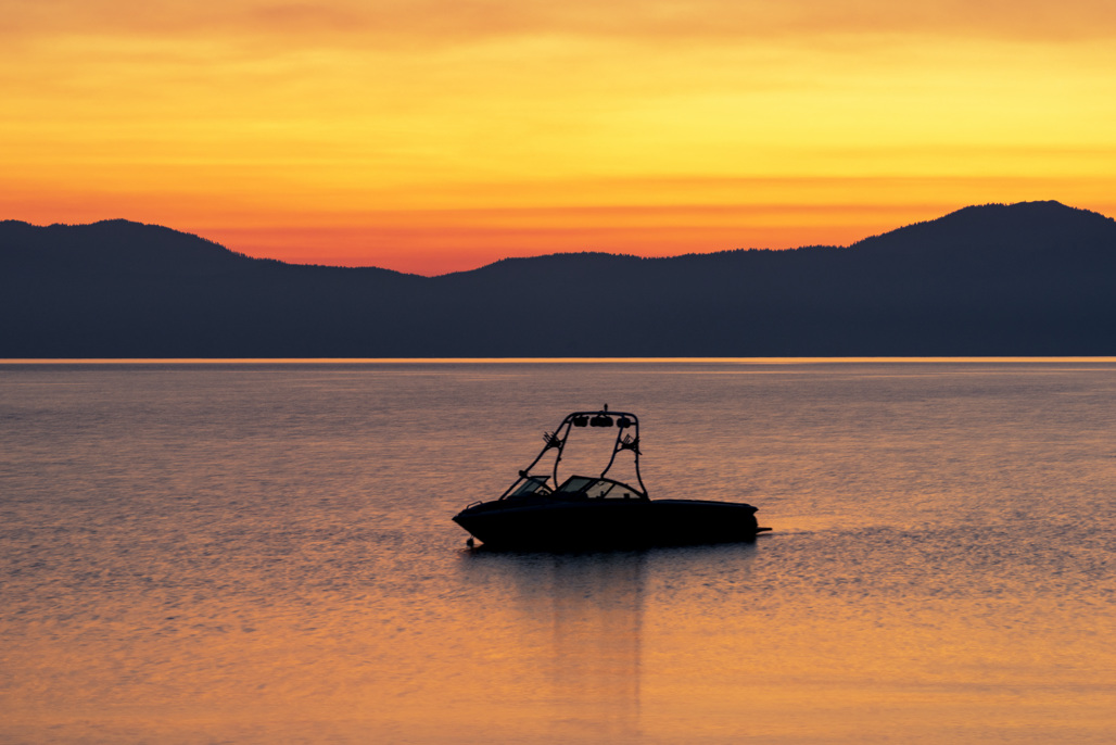
Campers and day use visitors enjoy swimming or scuba diving in the crystal clear water of Lake Tahoe, picnicking, relaxing on the warm sand of Lester Beach or Calawee Cove, and hiking the Rubicon Trail, Lighthouse Trail, and Balancing Rock Trail. Lester Beach is a popular location to launch your kayak, paddleboard, or canoe, but keep in mind that trailers are not allowed in the day use parking lots. Please check weather and wind conditions before venturing out on the lake.
The grandeur of the parks and their setting is a product of successive upheavals of the mountain-building processes that raised the Sierra Nevada. From promontories such as Rubicon Point in D.L. Bliss State Park you can see over one hundred feet into the depths of Lake Tahoe.
The park is named for a pioneering lumberman, railroad owner, and banker of the region. The D.L. Bliss family donated 744 acres to the State Park system in 1929.

Rubicon Trail (Pedestrian)
The Rubicon Trail (pedestrian) wraps around Emerald Bay, stretching from Emerald Bay State Park to D. L. Bliss State Park.
There are four main access points along the trail:
(1) at the North end of D.L. Bliss State Park is the Rubicon Trailhead starting at Calawee Cove
(2) 1.3 miles South is the Lighthouse Trailhead Parking Area (D.L. Bliss State Park)
(3) 5.7 miles south is Vikingsholm access, with a steep 1 mile hike to reach the Rubicon Trail from the Vikingsholm Parking Lot/Emerald Bay Overlook
If using the Emerald Bay Shuttle - this will be the closest access.
(4) the southern most trailhead of the Rubicon trail is 7.4 miles south at Eagle Point Campground (Emerald Bay State Park) 
The 7.4 miles of trail range from moderate to strenuous hiking and offer beautiful views of Emerald Bay and Lake Tahoe.
Emerald Bay and the Rubicon Trail are highly impacted in the summer.
Restrooms are available Memorial Day - Labor Day at Bliss, Boat Camp, and Vikingsholm.
No Dogs, No Fires, No Bicycles, No Camping, No Jumping/Diving
The parks are open from sunrise to sunset.
Cell Phones may not have reception - bring appropriate layered clothing, footwear and food and water. High Sierra weather varies and can change abrubptly. Check weather updates.
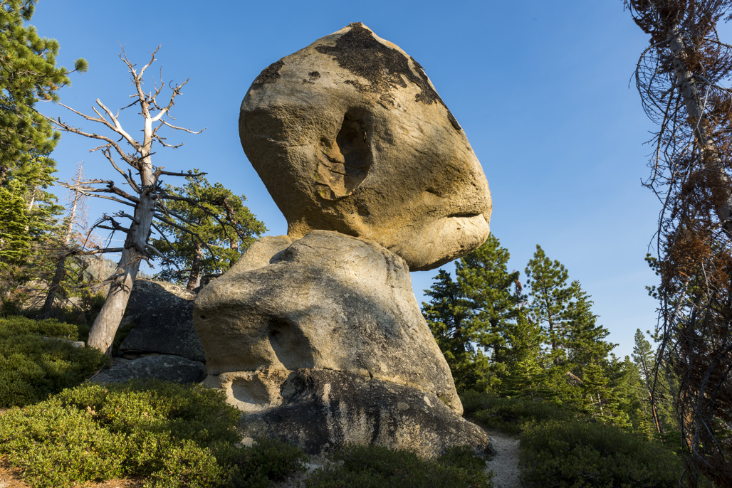
Balancing Rock Nature Trail
The Balancing Rock, "tons of granite resting precariously on a slender stone base", 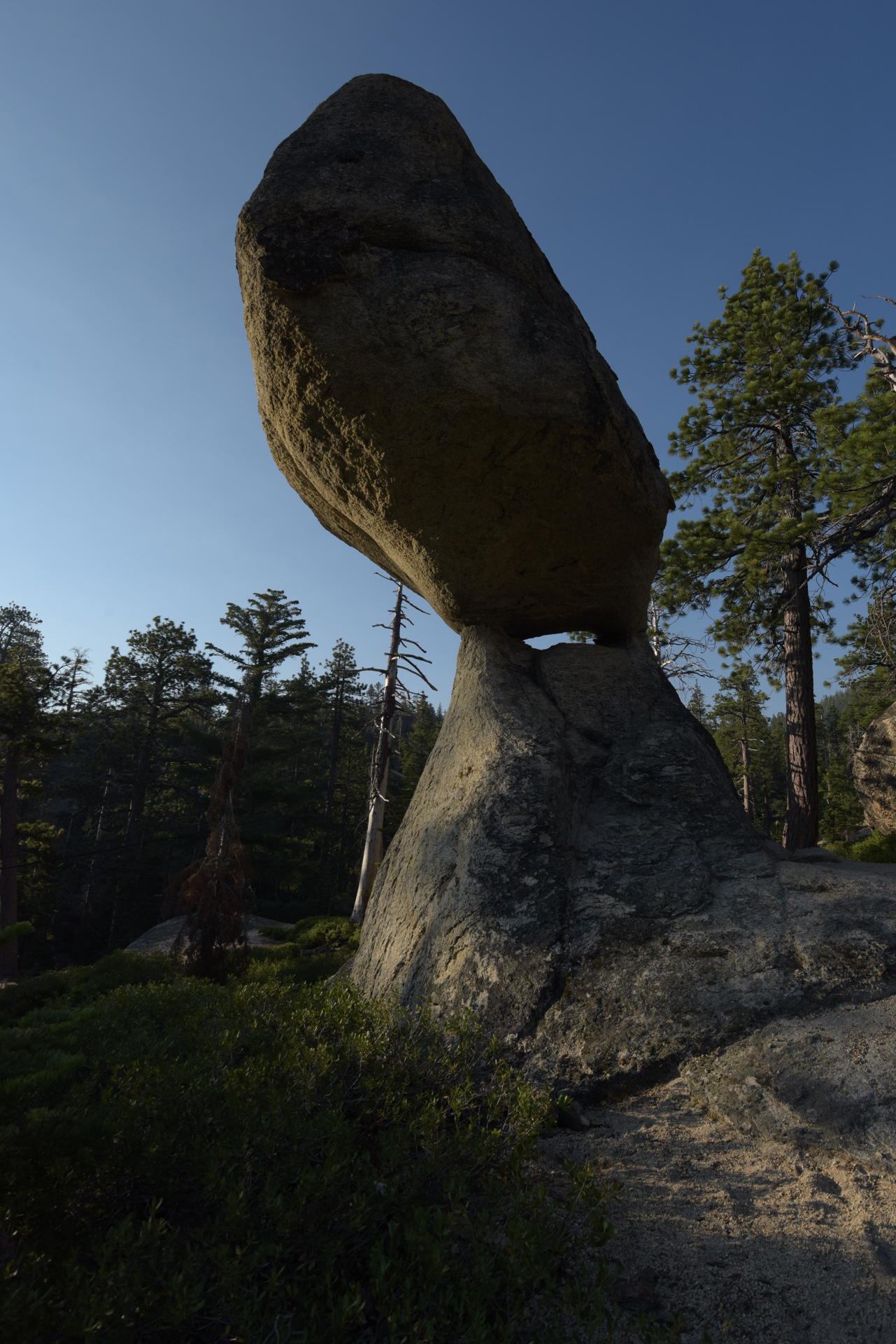 has long been a natural attraction on Lake Tahoe's western shore. Visitors to the Lake Tahoe area in the late 1800's and early 1900's enjoyed being photographed next to this geological marvel.
Today, the Balancing Rock is the feature attraction of a short, half mile self-guided nature trail in the northwest section of D.L. Bliss State Park. The granite of this large rock began weathering more rapidly at the joint plane, an extensive horizontal crack that is easily seen at its "waist".
The overlying rock weighs around 130 tons and is now balanced on the rock below. This precarious remnant of granite rock will eventually fall when enough material has eroded away to break the equilibrium between the two pedestals.