
Wilder Ranch SP - IMAP Pilot Project
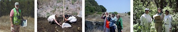
Inventory and Monitoring Tasks for the Pilot Project at Wilder Ranch State Park Included the Following:
VEGETATION
- Plant Communities Mapping
A geographic information system was used to produce a digital vegetation map for the park based on aerial photos and ground-truthing. Over five-hundred polygons were delineated for fifty different land cover types in the 7,250 acre park. See Wilder Ranch State Park Vegetation Mapping for a description of the vegetation map. - Sandhills Chaparral Community Composition
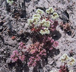
The sandhills chaparral plant community occurs only on a few sandy soil areas in the vicinity of Wilder Ranch SP. Data was collected for species composition, and a sampling methodology and design developed; however, only limited quantitative data on the sandhills chaparral community was collected for the pilot project. Wilder Ranch State Park Sandhills Assessment - Ben Lomond Spineflower (Chorizanthe pungens var. hartewegiana)
As a component of the sandhills plant community type, Ben Lomond spineflower (Chorizanthe pungens var. hartewegiana) occurs in openings where there is no overstory canopy cover. Monitoring recommendations were developed in order to detect significant changes in the occurrences and to take appropriate action early on. Wilder Ranch State Park Chorizanthe Study - Exotic Plants
Several species of invasive exotic plant taxa have become established in the Wilder Ranch SP coastal zone near the active agricultural lease areas. Locations of exotic species were included in the unit-wide vegetation map. - Santa Cruz Cypress (Cupressus abramisana)
The Santa Cruz cypress plant community is unique to the Santa Cruz area, with a significant portion of the community occurring inside Wilder Ranch SP. The U.S. Fish & Wildlife Service has proposed an inventory program for Santa Cruz County to determine the location of this plant community and its composition, and the IMAP team and District ecologists are cooperating with this project Wilder Ranch State Park Santa Cruz Cypress Study - Prairie Composition
Grassland areas on several topographic terraces have been inventoried and are being monitored by the Santa Cruz District natural resources specialists. The second year of data collection occured in spring 2001 and the NRD IMAP team members assisted the District staff as requested. The NRD IMAP team will assist the District effort by assisting with data analysis and preparation of GIS-based maps of sampling transects, if requested. - Forest and Woodland Composition
Forest and woodland plant community types at Wilder Ranch SP were identified during the vegetation mapping program. A detailed sampling program, including permanently established point-quarter and point-intercept transect methods, were used to inventory the species composition and size of trees, shrubs, and understory plant species in representative stands. See Wilder Ranch State Park Forest- Woodland Composition Study
WILDLIFE

- Small Mammals
Very little information existed on the small mammal assemblages at Wilder Ranch SP. This project consisted of identifying presence, distribution, and status of small mammals to provide a basic account of species in the park, and to develop a long-term monitoring strategy. Small mammal live-trapping, track-plates, and hidden automatic cameras were used in common vegetation types. Captured animals were identified to species, gender noted, weights and body measurements recorded, and then released. Eight different habitat types were sampled including Prairie, Redwood Forest, Chamise, Oak Woodland, Mixed Evergreen Forest, Knobcone Pine, Marsh, and Sandhills. Results of the study are contained in the following report: Wilder Ranch State Park Small Mammal Study - Medium and Large Mammals
The NRD IMAP team used track plates, spotlighting, hidden automatic cameras, and incidental sightings to inventory medium and large mammals. No captures were attempted. Wilder Ranch State Park Medium and Large Mammal Study - Birds: Shorebirds, Passerines, & Raptors
Point-count searches were performed to detect common bird species in the most common vegetation types. Upland birds were inventoried during the breeding season (May & June), and shorebirds were assessed during winter migration and stopovers at the shoreline (December). No nighttime survey for owls were conducted. Wilder Ranch State Park Landbird Study - Feral Pigs
Damage to selected vegetation types by feral pigs was inventoried. The extent and types of damage were documented, and maps prepared showing the locations of pig activity were made. No systematic attempt was made to count or census the pigs; however, models or indicators that others have developed relating pig damage to vegetation to numbers of pigs were used during analysis of the damage data. Wilder Ranch State Park Feral Pig Study - Amphibians and Reptiles
No systematic surveys were made for amphibians and reptiles, but incidental sightings during the course of other inventory and monitoring projects were recorded. Wilder Ranch State Park Amphibian and Reptile Study
AQUATIC ENVIRONMENT
- Salmonids
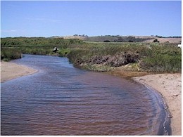
A contractor (Kawamoto Environmental Services, 6523 Claremont Ave., Richmond, CA 94805) was utilized to inventory and monitor salmonid species in Wilder Creek and Baldwin Creek. Water quality parameters and aquatic life habitat assessment was also part of this contract. Wilder Ranch State Park Freshwater Fish Study - Water Quality
Water quality and quantity was assessed in Wilder, Baldwin, and Majors Creeks. Methods included field measurements of chemical and physical properties including flow, surface water samples for chemical analysis, and collection and analysis of macroinvertebrate samples. A contractor performed taxonomic evaluations of macroinvertebrates. Wilder Ranch State Park Surface Water Quality Study and Wilder Ranch State Park Stream Macroinvertebrate Study. - Rocky Intertidal
The NRD IMAP team has investigated establishment of an inventory and monitoring program for the rocky intertidal areas in cooperation with the California Department of Fish and Game (CDFG) and/or the Monterey Bay National Marine Sanctuary. Wilder Ranch State Park Intertidal Invertebrate Study
PHYSICAL ENVIRONMENT
- Caves
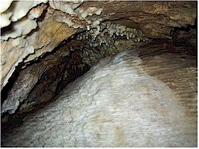
There are at least four limestone caves in Wilder Ranch SP that contain populations of at least four special status species of invertebrates, and significant geologic features. The NRD IMAP team and contractors performed the monitoring of cave vertebrates, invertebrates, and assessed the condition of geologic features in caves. See Wilder Ranch State Park Cave Biology Study for the report of the findings of cave wildlife. - Groundwater
Groundwater levels at Wilder Ranch SP may be affected by pumping for agricultural, landfill, or nearby sand-quarry use. The NRD IMAP team inventoried the existing condition of groundwater levels at Wilder Ranch SP by gathering information on locations and uses of groundwater wells, and past and current records for water levels and water quality in local wells. Wilder Ranch State Park Groundwater Study
Wilder Ranch State Park IMAP Project Agreement
The Project Agreement between the Natural Resources Division IMAP team and the Santa Cruz District, which contains additional details about the inventory and monitoring projects that will be conducted at Wilder Ranch State Park, is available at this link: