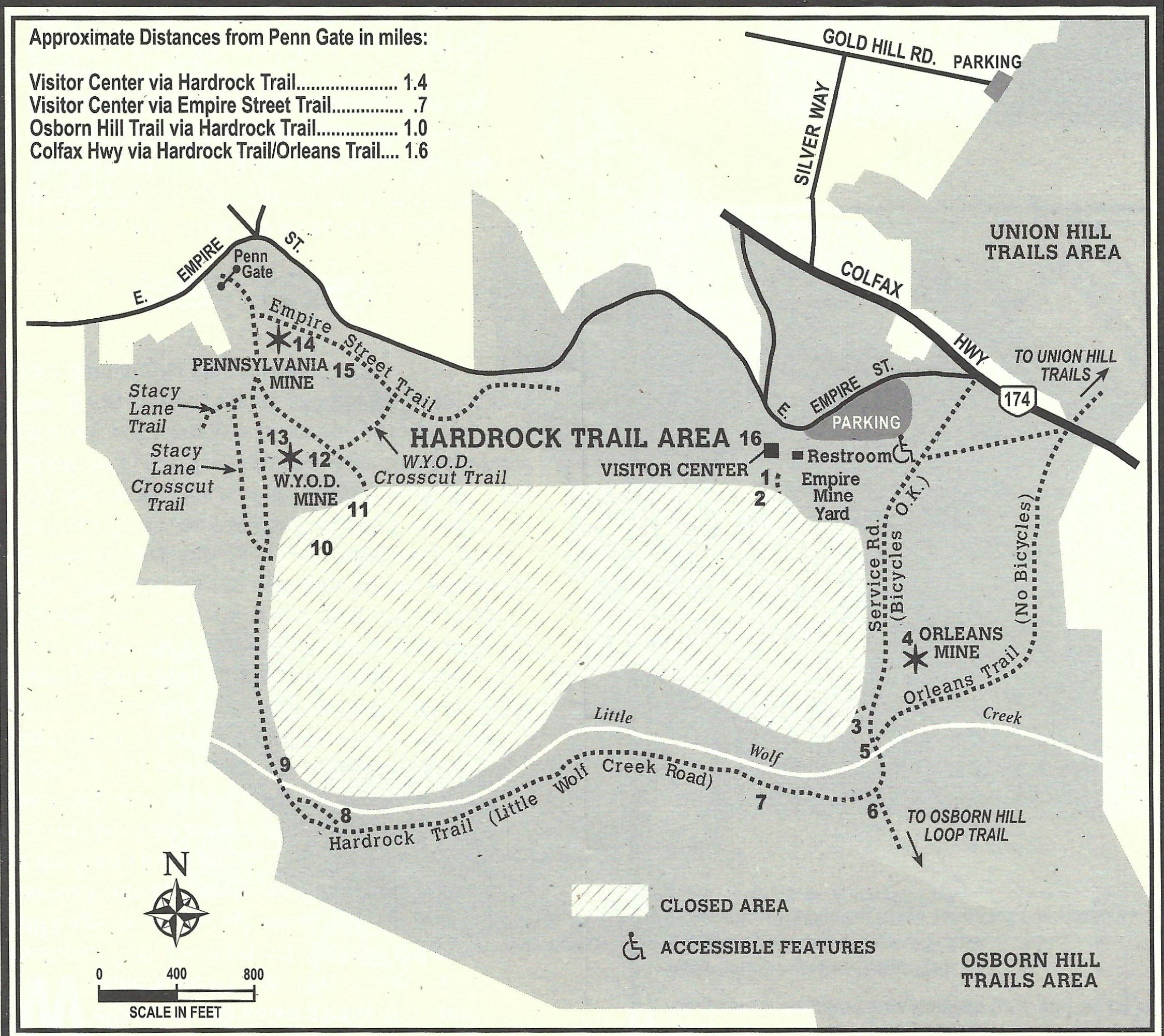
Hardrock Trail Area Self-Guided Tour

1. NARROW GAUGE CART TRACKS: Below the Railroad Crossing sign, the remails of narrow-gauge tracks can be seen in the pavement. Their route can be followed into the trees where the tracks carried carts from .....
2. HOIST A-FRAME: This support structure was used for unloading heavy equipment, and holding spools of new and used cable when the hoisting cables were reversed or replaced each year. Cables were reversed to even out wear, as the hoist ends were continually pinched during winding and the lower end was continually stretched by the weight of the cars.
3. ORLEANS STAMP MILL FOUNDATION: This foundation supported a stamp mill that was powered by a water-driven Pelton wheel. The mill crushed ore from the Orleans Mine until about the turn of the 20th century, when it became unprofitable.
To your right are the remains of concrete ramps that led onto large truck scales used around 1960 during rock crushing operations. Thousands of tons of waste rock have been hauled from this pile to be used as road fill.
Opposite the Orleans stamp mill foundation, the Orleans Trail branches off to cross Highway 174 and continues up to the Union Hill Trails.
4. ORLEANS MINE: The Orleans was once in fierce competition with the Empire Mine. But the Empire, under the leadership of William Bourn and later the Newmont Mining Corporation, eventually absorbed the Orleans and more than 60 other claims that were being worked on the Empire vein.
5. LITTLE WOLF CREEK RESTORATION AREA: The streamside environment of this creek is being restored to a more natural condition. Non-native blackberries, Scotch broom and other shrubs are being replaced with plants that belong in a stream environment. This is one example of how the park is working to protect California's natural resources.
6. TRAIL FORK (Osborn Hill Loop Trail): Here the Hardrock Trail turns west toward the Penn Gate. The Osborn Hill Loop Trail goes up the hill toward several abandoned mines.
7. LITTLE WOLF CREEK ROAD (Hardrock Trail): This road was built for trucks that carried waste rock from the Empire Mine to road construction sites to the southwest. Note the weigh-station foundation on the roadside.
8. DIVERSION DITCH: This ditch was dug to route Little Wolf Creek around the sand tailings area, thus avoiding possible contamination of the water.
9. SAND DAM: This portion of the Hardrock Trail was originally a trestle from which ore cars of the Pennsylvania Mine dumped waste rock. In time, enough rock was dumped that a road bed could be built for a narrow gauge rail line across Little Wolf Creek. Slurry accumulated in front of the waste rock. During wet years, the tailings area became a large settling pond. Eventually a spillway was added to control the flow into Little Wolf Creek.
10. SAND TAILINGS OVERLOOK (Closed to visitors): This barren plain was once a beautiful meadow with fruit trees. But after 1910, when slurry from the cyanide plant was first deposited here, the meadow became a large settling pond, and vegetation was destroyed. Nature is slowly reclaiming this area, covering some of the effects of man's relentless search for gold.
11. NORTH STAR WATER LINE (Closed to visitors): This 22-inch riveted-iron pipeline, built in 1897, carried water to the North Star Powerhouse. Traveling downhill from the Loma Rica Reservoir and crossing through the Empire Mine grounds from Union Hill to the Little Wolf Creek boundary, the water developed enough pressure to turn a 32-foot Pelton wheel in the North Star Powerhouse. This Pelton wheel is the world's largest. The North Star Powerhouse is now a mining museum operated by the Nevada County Historical Society.
12. W.Y.O.D. WASTE PILE: You have just climbed atop the largest waste pile in the park. This waste rock was taken out of the W.Y.O.D. Mine to make room for men and machinery. It was brought here in side-dumping cars that traveled on a rail line built on small trestles. The trestles and rails are gone, but the elongated mounds of rock show where they were located.
13. W.Y.O.D. MINE: The Work Your Own Diggins Mine got its name from the practice of leasing sections of a mine to individual miners, who then worked their own "diggins."
The W.Y.O.D. was an unlucky mine. The surface works first burned in 1898 and were rebuilt. In 1902 the courts ruled that the W.Y.O.D. vein was an offshoot of a vein owned by the Pennsylvania Mine. The W.Y.O.D. Mine was abandoned when the last surface works burned in 1912. Post caps of a large Comish pump bob and some machinery foundations are all that remain.
14. PENNSYLVANIA MINE: Up the hill are the concrete foundations of the Pennsylvania Mine's compressor house. From there a compressor supplied fresh air underground for the miners and compressed air for the drill and mechanical muckers. A hoist room was located in the far end of the building.
The Pennsylvania Mine's headframe, with its ore storage bins underneath, was built on the step-down foundations to the left.
The concrete buildings behind you housed transformers that were a part of the Pennsylvania's electrical system.
After the Empire acquired the Pennsylvania Mine 1912, ore was hauled to the Empire stamp mill over a narrow gauge electric railroad that ran parallel to what is now Empire Street.
15. MULE CORRAL: Before mules were lowered into the mine, they were kept in this corral made from old hoist cable and barbed wire strung between large pine trees.
16. EMPIRE MINE: You are back at the Empire Mine Yard. The trail ends in front of the Visitor Center, near the parking lot.
